
Gear
Backcountry Gear Guide for the Canadian Wilderness
A detailed breakdown of essential equipment for multi-day backcountry trips in Canada — from pack weight considerations to layering systems suited for alpine conditions.
Backcountry & Wilderness Navigation
Practical reference for backcountry travellers navigating Canada's wildest terrain — from reading topo maps to building a reliable gear kit and handling emergencies far from the trailhead.
Latest Articles
Three in-depth guides covering the core disciplines of backcountry travel in Canada — what to carry, how to navigate, and how to stay safe when conditions change.
Gear
A detailed breakdown of essential equipment for multi-day backcountry trips in Canada — from pack weight considerations to layering systems suited for alpine conditions.

Navigation
How to interpret contour lines, identify terrain features, and plan a route using 1:50,000 NTS maps — the standard for wilderness navigation across Canada.

Safety
Standard safety practices for backcountry travel in Canada — bear awareness, weather assessment, emergency signalling, and self-rescue considerations.
Route Planning
From the Rockies to Labrador, route planning in Canada means working with Parks Canada permit systems, variable trail conditions, and terrain that demands real navigation skills — not just a smartphone app.

Terrain
The 232-kilometre stretch between Banff and Jasper includes some of the most accessible yet genuinely demanding backcountry access points in the country. Elevation gains are moderate, but weather windows are narrow and river crossings require judgement.
Understanding how to read the terrain before leaving the trailhead is what separates a successful expedition from an unplanned bivouac.
Gear PreparationWilderness Navigation
GPS devices fail, batteries die, and satellite signal disappears under ridgelines. The ability to triangulate position with a Brunton compass and a 1:50,000 NTS topo remains non-negotiable for anyone travelling beyond marked trails in Canada.
Key Topics
Trail Maps & NTS Data
How to access and interpret Natural Resources Canada 1:50,000 topographic maps for backcountry planning.
Pack Weight & Layering
Weight targets, layer systems, and the trade-offs between ultralight setups and Canadian weather demands.
Bear Safety & Food Storage
Bear canister requirements, bear spray carry protocols, and hanging systems for regions without metal boxes.
River Crossings
How to assess crossing points, unbuckle hip belts before entry, and what to do when water levels rise unexpectedly.
Emergency Communication
PLB registration, satellite messenger use, and filing trip plans with local emergency management offices.
Leave No Trace in Canada
Parks Canada's LNT standards, designated camping zones, and grey water disposal protocols in sensitive alpine terrain.
Jasper National Park
Jasper's backcountry network covers over 1,200 km of trail, with route-finding challenges that range from well-marked warden trails to unmarked alpine traverses requiring full navigation competency.
Several zones require designated campsite bookings through Parks Canada's reservation system — permits fill well before the season opens.
Safety Protocols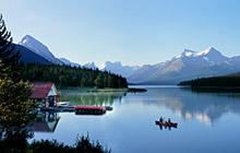
Contact
Questions about backcountry conditions, route suggestions, or content corrections are welcome. Responses are sent within two business days.
Start with the gear guide, then review the navigation and safety articles before your next permit application.